By Mabel Plaskett
We left Pacific Valley Sept. 27 driving north, Vi Lowe (Mrs. John) and I. Both “Coast natives” with a deep inherent love for our Monterey County coast homeland, we meant to see for ourselves if there were places more beautiful.
Vi’s mother, Mrs. W. E. Plaskett joined us in Salinas and we headed up the Cabrillo Highway known as Highway 1.
From Santa Cruz to Davenport and Pescadero there was bleak countryside, but with interesting rock formations and little beaches. We passed Half Moon Bay and crossed the Golden Gate Bridge. The first bridge to be built over a major harbor entrance. Its towers are 746 feet above water level, the highest in the world. Alcatraz Island seemed very near on our right.
From Sausalito north was uneventful. We stopped for lunch at Tomales Bay. It was a clear day and we saw many fishing boats off Bodega Bay. All along the coast here are oyster beds in the quiet coves.
We stopped at Fort Ross in Sonoma County, 13 miles north of the Russian River, which was built by the Russians in 1812 who, with the Aleut Indians from Alaska, farmed and hunted to provide food for the Russian ships and towns in the frozen north. They sold out to General Sutter in 1841 and withdrew to Alaska. The stockade, lookout tower and Greek Orthodox Chapel have been restored as a State monument.
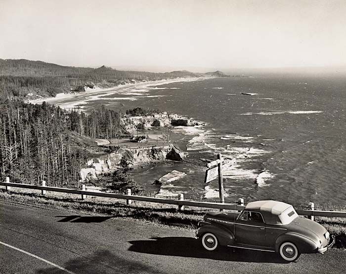
THE NORTHERN part of Highway 1 is very narrow with sharp and frequent horseshoe curves. We saw scattered ranch houses and sheep grazing all along the road. At Fort Bragg we stayed overnight, having dinner at The Breakers at the mouth of the Noyo River. This is a fishing village and a very beautiful place.
From Eureka to Crescent City we passed beautiful coast line, many lagoons. The old town of Trinidad received its name from the Spanish navigators. Bodega and Heceta, who entered the Bay on Trinity Sunday, June 9, 1775. On Trinidad Head near the light house stands a granite cross, a memorial to the Spanish discoverers.
At Prairie Creek State Park is a beautiful grove of redwoods, hemlock and spruce. One of the last bands of the Roosevelt Elk roam here. As I walked near a mother Elk with her baby trying to get a closeup, she charged at me and I had to run for the car. The caretaker’s wife from her fenced in yard, said she would not venture among them for anything.
The Del Norte State Park has some wonderful stands of redwood. Here stands the “Founders Tree”, 364 feet high.
At Crescent City we left Highway 1 taking 199 to Cave Junction as we wanted to explore the Oregon Caves. The Caves are 19 miles off the main road, in the heart of the Siskiyou, 4,000 feet above sea level. They were discovered by Elijah Davidson in 1874, while hunting as he followed a wounded bear into the Caves. The bottom of the Caves is reached by means of ladders and paths. This is 280 feet below the surface. The Caves have many chambers and caverns with interesting formations of fantastic and grotesque shapes caused by the deposit of lime.
BACK ON the 199 we head for Crater Lake, one of the highlights of the trip. Crater Lake is a startling blue and one of its charms is that the entire lake can be seen at one time although the lake is six miles wide and has twenty miles of shore line. The surrounding cliffs range from 6,000 to over 8,000 feet in elevation. The Phantom Ship, an island in the lake, is brilliantly reflected in the water. And Wizzard Island is actually a volcano within a volcano.
Although Crater Lake was well known to the Klamath Indians, it was not until June 12, 1853, that the first white man saw the lake. Don Wesley Hillman, a prospector, looking for the Lost Cabin Mine, from the top of a ridge suddenly saw the lake spread out before him. He named it The Deep Blue Lake. Later it was called Lake Majesty until someone gave it the present name of Crater Lake.
Leaving the Lake at the north entrance, through Lodge Pole Pine Forest to Diamond Lake where we spent the night. This is a beautiful lake and a fisherman’s paradise. This was our coldest experience, the thermometer going down to 21 that night. In spite of that, at seven in the morning, we saw men in boats fishing in the lake.
From Diamond Lake we hit the 97 Highways and followed a straight road line with dense pine forest all the way to Bend. This became slightly monotonous. We drove along the Deschutes River which means “The Rapids,” stopped at Redmond to buy Indian moccasins and crossed the Crooked River Bridge between Madras and Redmond.
NEAR BEND we admired the world famous Peterson’s rock garden. A Danish immigrant Rasshuss Petersen came to Central Oregon in 1906. He started collecting rock in 1935 and millions of them make this a beautiful work of art. At Madras we took the 26 Highway to Mt. Hood. All along the way the Three Sisters Mountains, Washington Peak and Mt. Jefferson were in sight. These, however, were dwarfed in comparison to majestic Mt. Hood.
We reached Timberline Lodge on the day before it closed. The Lodge is 6,000 feet in elevation and is the center of famous winter sports. It opens again Nov. 15 for the winter season. The summit of Mt. Hood has an altitude of 11,245 ft. Nine glaciers sprawl all directions toward the green slopes of the mountain which may be seen from all over the state.
Leaving Mt. Hood we proceeded on the Mt. Hood loop, passed The Dalles and stayed that night at Meredith Lodge near Hood River on the very bank of the mighty Columbia. Here we had a magnificent view, looking across the river to the state of Washington. The river seemed quiet here with cabin cruisers going by.
The next morning we drove along the Columbia River toward Portland, passing Bonneville Dam. We breakfasted in the Lodge at the Multnomah Falls. With a drop of 620 feet into the gorge of the Columbia River, this is one of the most outstanding attractions of the famous Columbia River Highway.
WE CONTINUE passed many beautiful water falls including Latourell, Bridal veil, Wahkeena, Horsetail and many others. This is a very beautiful drive.
We turned south at Portland to visit the capitol at Salem. The beautiful new administration building has murals depicting the history of Oregon. In front are statues of Lewis and Clark with Sacajawea, the Indian girl, who led them across the Oregon trail.
We continued south along the Willamette River on the 99 west to Junction City where we took Highway 36 along the Suis-River to the coast at Florence. Here we spent the night.
In the morning we drove north to the Sea Lion Caves. These caves are reached by an elevator going down 208 feet opening, into a tunnel leading to the caves. Here thousands of sea lions come for winter headquarters. Most are Stellar sea lions with a few smaller California sea lions. The large Stellars roar while the California sea lions bark.
The attendant told us the bulls each have a harem of 12 to 15 females. They have their young early in June. The new born pups weigh from 30 to 40 lbs., a single offspring to each cow. The large bulls weigh 2,000 lbs. These are Willows where we stayed the huge, warm-blooded, intelligent, air-breathing mammals and are a wonderful sight. We are told this is the only year round home of the sea lion. This cave was discovered by a retired sea captain named Cox, who rowed his skiff into the cave at low tide one calm day in 1880.
THESE CAVES are 2,000 feet long. On the floor of the higher cave, out of water, is a mummified sea lion. He crawled up on the floor hundreds of years ago and died. It is believed the oil in the blubber, the air currents and the soil in which it is imbedded preserve it. As we listen to the barking of the smaller seals, we are reminded of our own coast where one can hear them most any time.
We now turn south past Coos Bay, Coquille down the coast to Port Orford south of this at Gold Beach the Rogue River empties into the ocean. There is a tremendous lumber operation here as there is all along the Oregon coast.
Soon we are back in California and at Crescent City encounter our first fog. We stayed the night at Klammath and near Arcata we took the 299 Highway across the mountain to Redding. We visited Shasta Dam where the water was at its lowest ebb, and drove to night. Leaving Willows early the next morning, we had breakfast with old friends the McGrews at Woodland and reached Salinas shortly after noon. Here we leave Vi’s mother and proceed to Monterey and south to Pacific Valley. After eight days of travel, through some of the most beautiful scenery in the world, we still think our coast is a wonderful place to be.
Mabel Sans Plaskett was born in Coralitas near Ben Lomond in the Santa Cruz Mountain area of California. Her father Edward Robert Sans ran a saw mill near Pacific Valley, along the Nacimiento - Ferguson road to the coast at Highway One. It was there she met Edward Abbott Plaskett, her husband. Mabel wrote about the coast and the pioneers of the 19th and 20th Centuries.
Recent Comments